“A well-designed map has transcendental power and can be easily understood and translated by everyone everywhere regardless of literacy or language” – Bernard Nietschmann, 1995
CAMP is informed and inspired by other mapping projects built around topics like environmental justice, indigenous land and resource rights, and keeping fossil fuels in the ground.
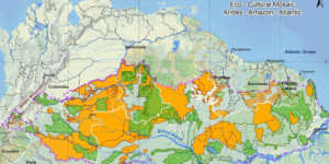
RAISG – Online Map of the Amazon
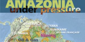 Red Amazonica de Informacion Socioambiental Georreferenciada (RAISG, or the Amazon Geo-Referenced Soicio-Environmental Information Network) is a project to coordinate and exchange information for the collective rights, sustainability, and social and environmental diversity of the Amazonian region. Resources and reports are available on the RAISG website in Spanish, and a 2012 report “Amazonia Under Pressure” (English) includes data and analyses on roads, oil and gas, mining, hydroelectric plants, fires and deforestation. Their 2015 online map – similar to CAMP – shows fossil fuel extraction, indigenous territories, and protected areas in the Amazon.
The Environmental Justice Atlas
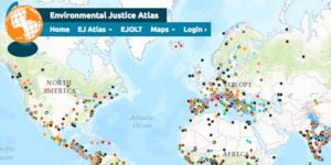 The EJAtlas documents and catalogues social conflict around environmental issues, aiming to make these mobilization more visible, highlight claims and testimonies and to make the case for true corporate and state accountability for the injustices inflicted through their activities. It also serves as a virtual space for those working on EJ issues to get information, find other groups working on related issues, and increase the visibility of environmental conflicts.
Mapping Fossil Fuel Resistance
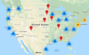 This map from 350.org and Power Shift Network is a resource to help new and existing pipeline fighters build community and become aware of their allies. Community groups, organizations and student clubs that are actively fighting oil and gas projects are invited to add their information to the map. The purpose of the map is to provide a bird’s-eye view of the important organizing happening across the continent, and give people a way to find and get involved in local fights in their community.
Landmark
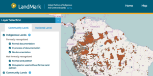 LandMark’s Global Platform of Indigenous and Community Lands is a dynamic, online mapping platform that provides critical information on the collective land and natural resource rights of Indigenous Peoples and local communities around the world. The global platform supports local livelihoods and well-being by increasing the visibility of indigenous and community lands and presenting crucial information on the state of land rights.
Fossil Fuels on U.S. Public Lands
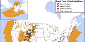 The Center for Biological Diversity is working alongside allies in a national Keep It in the Ground campaign, making a historic push (through appeals, lawsuits, legal petitions, and strategic media and organizing) to keep U.S. publicly owned fossil fuels in the ground, out of the atmosphere. Their 2015 report includes a map of fossil fuels on U.S. public lands. The Obama administration has leased nearly 15 million acres of public land and 21 million acres of ocean to the fossil fuel industry. More than 67 million acres — an area 55 times larger than Grand Canyon National Park — are now leased.
FracTracker Alliance
![]() The FracTracker Alliance studies, maps, and communicates the risks of oil and gas development to protect our planet and support renewable energy transition. The have maps showing oil and gas projects as well as an Alliance Map that shows organizations working on oil & gas issues. View maps by region or topic, including climate change, economics, health and infrastructure.
The FracTracker Alliance studies, maps, and communicates the risks of oil and gas development to protect our planet and support renewable energy transition. The have maps showing oil and gas projects as well as an Alliance Map that shows organizations working on oil & gas issues. View maps by region or topic, including climate change, economics, health and infrastructure.
The Path of the Anacondas
 The Path of the Anacondas is an initiative that aims to consolidate the result of three decades of work in the Northern Amazon Region, taken forward by government and non-government entities and applied through projects, policies and conservation models. This work includes the declaration of protected areas and the recognition of indigenous territories. The initiative sees the protection of the Northern Amazon Region as the world’s largest solution to climate change.
CartoCrítica
CartoCrítica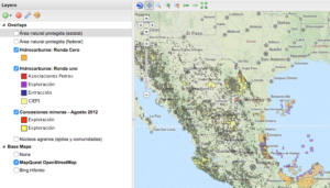 is an independent Mexican initiative by Manuel Llano, which aims to promote transparency and access to public information using geospatial technology and critical cartography in defense of territory, the promotion of human rights, and environmental conservation. The project’s interactive map of petroleum, gas and minerals overlays this data with protected natural areas and agrarian centers (ejidos and communities).
Mapping Environmental Injustice in Mexico
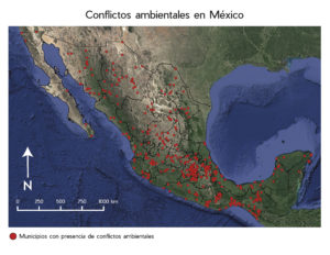 The Research Institute in Ecosystems and Sustainability of the UNAM (National Autonomous University in Mexico) has mapped 560 socio-environmental conflicts in Mexico between 2012 and 2017. The maps are based on analysis of articles from the newspaper La Jornada and other sources. The conflicts were categorized by issue type, including (from most to least common): mining, water, energy, mega-tourism projects, urban expansion, forestry, agriculture, toxic and hazards waste, road construction, fishing and biotechnology. An article about the research was published by the Union of Scientists Committed to Society (Unión de Científicos Comprometidos con la Sociedad, or UCCS) in March 2018.
Anti-Eviction Mapping Project
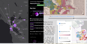 The Anti-Eviction Mapping Project is a data-visualization, data analysis, and storytelling collective documenting the dispossession of San Francisco Bay Area residents in the wake of the Tech Boom 2.0. Through digital maps, oral history work, film, murals, and community events, the project renders connections between the nodes and effects of new entanglements of global capital, real estate, high tech, and political economy.
Nova Cartografia Social Da Amazônia
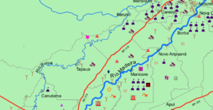 Nova Cartografia Social Da Amazônia (New Social Cartography Project of the Amazon) works alongside indigenous, traditional, and quilombola communities to map regional resource conflicts. The project aims to support self-mapping by traditional communities in the Amazon. The materials produced through these collaborations support education around resource conflicts and help strengthen existing social movements.
Iconoclasistas
 Iconclasistas is an Argentine mapping collective that works with movement organizations on data collection projects that protect the common good. Many of the collective’s maps are centered around resistance efforts against mining, oil extraction, and agribusiness in Argentina and Latin America at large.
Cross-border Infrastructure Projects
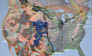 A set of 2016 maps from Parag Khanna’s book Connectography show major cross-border infrastructure projects in different regions of the globe. “Major world regions are forging dense infrastructural connectivity and reorienting their relations around supply chains rather than borders.”
Saskoil
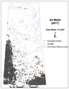 Saskoil.org is an independent information hub about the social and environmental impacts of oil in Saskatchewan. This site presents information about the oil industry and its extraction techniques, including profiles of real people living with and sustaining the oil economy. Saskoil has maps of oil and gas wells, horizontal fracked wells, oil steam wells and suspended wells.
End Amazon Crude Oil
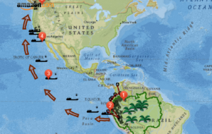
A story map created by students at the University of California, Santa Cruz that draws on storytelling and advocacy by Amazon Watch. “The Amazon rainforest may seem like a faraway place to most people. But we are connected in our daily lives in more ways that we might think—from our weather to the gas we put in our cars.”